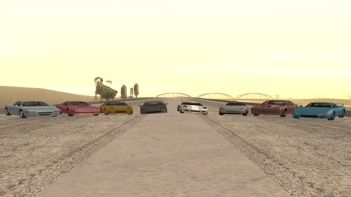
Want to see how good of a driver you are? Do races in CnR! Simply type /challenge and go to the designated starting checkpoint. The first time is free and each attempt raises the price. You win money by setting a top 10 rank. Certain challenges require a specific car.
Point To Point - Race Challenges have a fixed start point
Circuit - Race Challenges will determine the closest point at which to start the challenge.
Note: Traffic and other obstacles are part of the challenge!
Race Challenge Records
Opens In A New Window
- San Andreas Tour
- Chiliad Climb
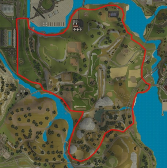
- Around San Fierro
- Desert Highways
- Around Los Santos
- Red County Run
- SF To LS
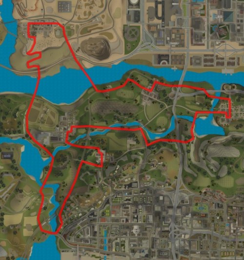
- Flint County Scenic Route
- Around Las Venturas
- Missionary Hill Climb
- Trucker Challenge
- Admin Hill
- Los Santos Circuit
- Back O Beyond Trail
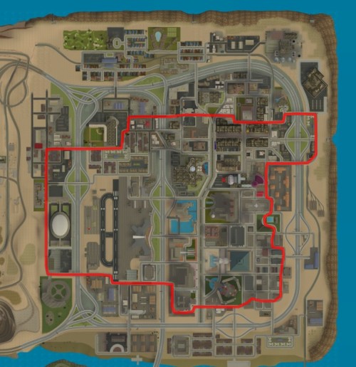
- East Los Santos
- Dam Rider
- Boating With Jaws
- Desert Trail
- Hills Of San Fierro
- LV Biker Endurance
- Las Venturas Fly-By
- San Fierro Bay
- Bridges Of San Fierro
- San Fierro Fly-By
- Farm Roads
- High Speed Los Santos
- Boat Ride
- LS Helicopter Tour
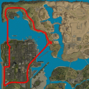
San Andreas Tour
This Challenge will take you around San Andreas, passing by Los Santos, Las Venturas and San Fierro. This is the longest challenge, and takes place mostly on Highways or Main Roads.
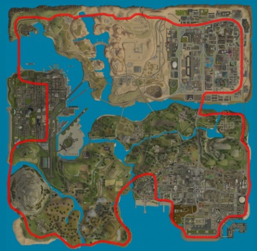
Challenge Type: Circuit
Distance: 27.5 Km
Road Conditions: Highways
Direction: Counter-Clockwise
Difficulty: Medium
Vehicles: Land Vehicles/Car
Chiliad Climb
Get to the top of Mt.Chiliad as fast as possible! This is a simple challenge, that starts at the bottom of Mt.Chiliad and ends at the top.

Challenge Type: Point To Point
Distance: 2.5 Km
Road Conditions: Dirt Trails
Start Point: Bottom of Mt.Chiliad
End Point: Top of Mt.Chiliad
Difficulty: Medium
Vehicles: Land Vehicles
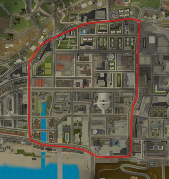
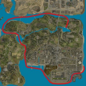
Around San Fierro
This Challenge goes around the outer edge of San Fierro. While fairly easy, this Challenge has a few difficult areas. San Fierro traffic, especially around the Police Department, should make this Challenge quite interesting.
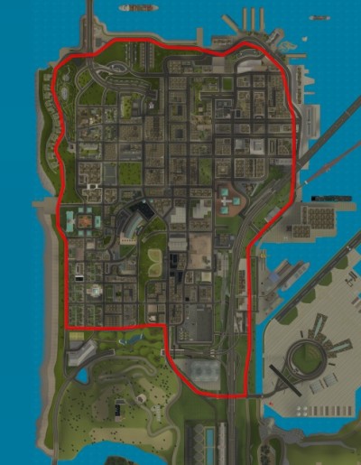
Challenge Type: Circuit
Distance: 6 Km
Road Conditions: City Roads
Direction: Clockwise
Difficulty: Medium - Hard
Vehicles: Land Vehicles
Desert Highways
Desert Highways is a fast Challenge on main roads in the desert. This Challenge passes by Fort Carson, Las Payasadas, El Quebrados and Las Barrancas. Bring a fast car!
Challenge Type: Circuit
Distance: 7.5 Km
Road Conditions: Desert Highways
Direction: Counter-Clockwise
Difficulty: Medium - Hard
Vehicles: Land Vehicles
Around Los Santos
This Challenge goes all the way around the outer edge of Los Santos, following mostly main roads.

Challenge Type: Circuit
Distance: 7 Km
Road Conditions: City Roads
Direction: Clockwise
Difficulty: Medium - Hard
Vehicles: Land Vehicles
Red County Run
Discover the back country trails of Red County! This Race Challenge begins at the Panopticon Logging Camp and ends in Las Colinas in Los Santos. This Challenge takes place mostly on dirt trails, so off-road vehicles are strongly suggested.

Challenge Type: Point To Point
Distance: 6 Km
Road Conditions: Off Road
Start Point: The Panopticon
End Point: Las Colinas
Difficulty: Hard
Vehicles: Land Vehicles
San Fierro To Los Santos
Get from Pier 69 in San Fierro to Downtown Los Santos as fast as possible! Traffic should be minimal for this Race Challenge, but the route is difficult. Be especially careful when you reach Flint County!

Challenge Type: Point To Point
Distance: 7 Km
Road Conditions: Country Roads
Start Point: Pier 69 in San Fierro
End Point: Downtown Los Santos
Difficulty: Hard
Vehicles: Land Vehicles
Flint County Scenic Route
Visit the country, at an extreme speed! This Race Challenge takes place on the country roads of Back'O'Beyond and Flint County, passing by the San Fierro Airport.
Challenge Type: Circuit
Distance: 8 Km
Road Conditions: Country Roads
Direction: Counter-Clockwise
Difficulty: Medium-Hard
Vehicles: Land Vehicles
Around Las Venturas
This Race Challenge goes around the city of Las Venturas. Many sharp corners, especially on the east side, should make this Challenge great for drifting. Watch out for Las Venturas traffic!
Challenge Type: Circuit
Distance: 6.5 Km
Road Conditions: City Roads
Direction: Clockwise
Difficulty: Medium-Hard
Vehicles: Land Vehicles
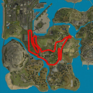
Missionary Hill Climb
This Race Challenge begins at the Avispa Country Club in San Fierro. From there, it goes up Missionary Hill and then go back down into Foster Valley. After passing by the San Fierro Stadium, the Challenge then ends back at the Avispa Country Club.
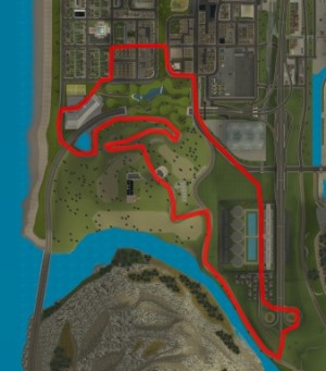
Challenge Type: Point To Point
Distance: 5 Km
Road Conditions: Hills and City Roads
Start Point: Avispa Country Club In San Fierro
End Point: Avispa Country Club In San Fierro
Difficulty: Medium-Hard
Vehicles: Land Vehicles
Trucker Challenge
This Race Challenge for Trucks only begins and ends at RS-Haul Trucking in Flint County. The Challenge passes by Fort Carson and all the Red County towns, which makes it one of the longest Challenges.
Challenge Type: Point To Point
Distance: 12 Km
Road Conditions: Country Roads
Start Point: RS-Haul Trucking In Flint County
End Point: RS-Haul Trucking In Flint County
Difficulty: Medium-Hard
Vehicles: Trucks Only
Admin Hill
Visit the Admin Houses! This Race Challenge goes around Admin Hill in Richman. Sharp turns, small roads and many bumps and hills make this Challenge quite difficult.

Challenge Type: Circuit
Distance: 3.5 Km
Road Conditions: Hills
Direction: Counter-Clockwise
Difficulty: Hard
Vehicles: Land Vehicles
Los Santos Circuit
The Los Santos Circuit is a short, fast race around a small section of Los Santos. This is a high speed circuit, without many turns, so be sure to use a fast car!
Challenge Type: Circuit
Distance: 3 Km
Road Conditions: Main City Roads
Direction: Counter-Clockwise
Difficulty: Medium
Vehicles: Land Vehicles
Back'O'Beyond Trail
The Back'O'Beyond Trail Challenge begins and ends at the Sawmill in Angel Pine, and takes place entirely on dirt trails. Off Road vehicles are suggested for this Challenge.
Challenge Type: Point To Point
Distance: 4.5 Km
Road Conditions: Dirt Trails
Start Point: Sawmill in Angel Pine
End Point: Sawmill in Angel Pine
Difficulty: Hard
Vehicles: Land Vehicles
East Los Santos
This Race Challenge goes around East Los Santos, passing by the Stadium, Las Colinas and Downtown Los Santos. Watch out for extra Traffic near the Los Santos Police Department area.

Challenge Type: Circuit
Distance: 4.5 Km
Road Conditions: City Roads
Direction: Counter-Clockwise
Difficulty: Hard
Vehicles: Land Vehicles
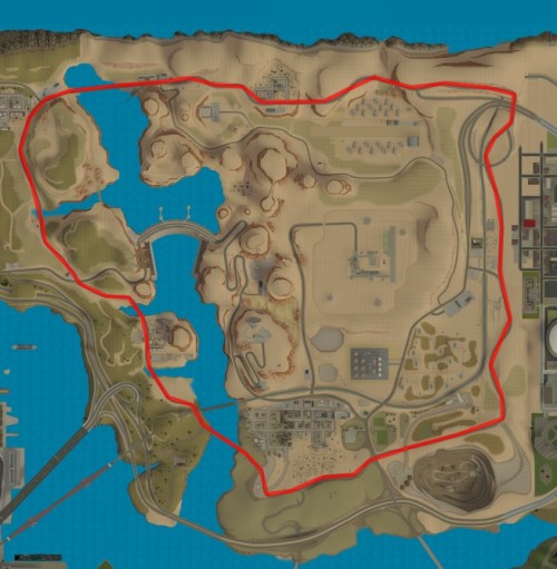
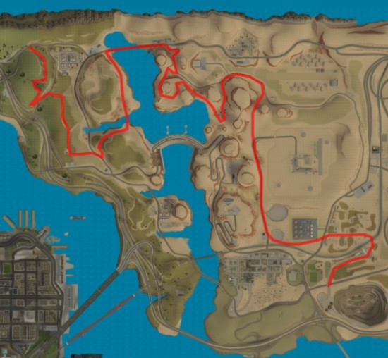
Dam Rider
This Race Challenge takes place in the Desert and Tierra Robada, passing by Fort Carson, El Quebrados and Verdant Meadows. As the name implies, the Challenge crosses the Sherman Dam. Be careful in the curves before the dam!

Challenge Type: Circuit
Distance: 8.5 Km
Road Conditions: Desert Roads and Highways
Direction: Counter-Clockwise
Difficulty: Hard
Vehicles: Land Vehicles
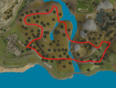
Boating With Jaws
If you're up for a real Challenge, you have to try this one. This Race Challenge for Boats will take you through the Red County rivers, a waterway which is known for it's high shark population. Be very careful around sharp corners!
Challenge Type: Circuit
Distance: 7.5 Km
Road Conditions: Water
Direction: Clockwise
Difficulty: Very Hard
Vehicles: Boats Only
Desert Trail
This Race Challenge explores the trails of the Desert. Beginning in Tierra Robada near El Quebrados and ending at the Quarry, this Challenge takes place mostly on Dirt Trails. Off Road vehicles are suggested for this Challenge, however tall vehicles are not recommended, due to a section passing under a pipeline in Octane Springs.
Challenge Type: Point To Point
Distance: 7 Km
Road Conditions: Dirt Trails
Start Point: Tierra Robada
End Point: The Quarry
Difficulty: Hard
Vehicles: Land Vehicles
Hills Of San Fierro
The Hills Of San Fierro Race Challenge is a short circuit through San Fierro. A Fast Vehicle is suggested for this Challenge, but the Hills and Jumps make it difficult.

Challenge Type: Circuit
Distance: 3 Km
Road Conditions: City Roads and Hills
Direction: Counter-Clockwise
Difficulty: Medium-Hard
Vehicles: Land Vehicles
Las Venturas Biker Endurance
This Race Challenge for Bikes only goes around the outer edge of Las Venturas, with a small detour into the Redsands area. This Challenge has many small, tight turns, so be careful!

Challenge Type: Circuit
Distance: 9 Km
Road Conditions: City Roads
Direction: Clockwise
Difficulty: Medium-Hard
Vehicles: Bikes Only
Las Venturas Fly-By
Fly through and around Las Venturas as quickly as you can! The start and end point is at Verdant Meadows.

Challenge Type: Circuit
Distance: 12.54 Km
Road Conditions: Air
Direction: Counter-Clockwise
Difficulty: Medium - Hard
Vehicles: Air Vehicles
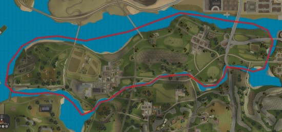
San Fierro Bay
Staying close to the shore for this one. Heads up north towards Bayside then back south down Tierra Robada. Be careful, jaws likes the shores!

Challenge Type: Point To Point
Distance: 8.21 Km
Road Conditions: Water
Start Point: Easter Bay Airport
End Point: Sherman Reservoir
Difficulty: Medium
Vehicles: Boats Only
Bridges Of San Fierro
You'll be mainly on the highway for this quick circuit, travelling across the bridges of san fierro. Expect traffic when you are inside the city!
Challenge Type: Circuit
Distance: 9.07 Km
Road Conditions: Hill Roads and Highways
Direction: Counter-Clockwise
Difficulty: Easy
Vehicles: Land Vehicles
San Fierro Fly-By
You'll be flying close to many trees in this challenge. So keep a sharp eye out for them! The start and finish point is at Easter Bay Airport.

Challenge Type: Circuit
Distance: 10.49 Km
Road Conditions: Air
Direction: Clockwise
Difficulty: Hard
Vehicles: Air Vehicles
Farm Roads
Windy hill roads can make this challenge harder in certain vehicles, watch out for sharp turns.
Challenge Type: Circuit
Distance: 10.15 Km
Road Conditions: Country Roads
Direction: Counter-Clockwise
Difficulty: Medium
Vehicles: Land Vehicles
High Speed Los Santos
Fast roads for this track. Passes through the north of LS, cuts through Palomino Creek and into Red County.

Challenge Type: Circuit
Distance: 9.90 Km
Road Conditions: Highways and Main City Roads
Direction: Counter-Clockwise
Difficulty: Easy
Vehicles: Land Vehicles
Boat Ride
This challenge starts from the Fisher's Lagoon and follows the Red County coastal line until you get to the Santa Marina Beach where it then continues along the beaches to the end in Playa del Seville. Watch out for the jaws and low bridges on the way!
Challenge Type: Point To Point
Distance: 10.53 Km
Road Conditions: Water
Start Point: Fisher's Lagoon
End Point: Playa del Seville
Difficulty: Hard
Vehicles: Boats Only
LS Helicopter Tour
Fly through Los Santos! Be careful to dodge any trees and buildings though! You'll be starting and finishing at Los Santos Airport.

Challenge Type: Circuit
Distance: 9.79 Km
Road Conditions: Air
Direction: Clockwise
Difficulty: Hard
Vehicles: Air Vehicles